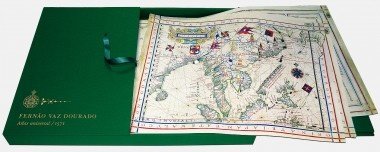
Universal Atlas of Fernão Vaz Dourado, 1571
- Autoria
João Carlos Garcia, Amélia Polónia, Maria Fernanda Alegria, Alexandra Curvelo, Sónia Domingos, Teresa Araújo, Ana Fialho
- Edição
- Barcelona: M. Moleiro
- Ano
- 2013
- Nº de Páginas
- 572
- ISBN
- 978-84-96400-85-6

Resumo (Inglês)
In the mid-16th century, while Rome, Venice, Leuven and Antwerp printed hundreds of charts and maps, Vaz Dourado applied and emphasised the premises of the most refined techniques of Renaissance miniature painting: he used pristine white parchment, the drawings were meticulous and detailed, the rich palette was skilfully enhanced by the use of gilt, transforming these atlases into singular, sophisticated and valuable items, set well apart from mere printed works.
This sublime example of sumptuous cartography seems to owe more to the art of illumination than to cartography. Although little is known for sure about the mapmaker, Fernão Vaz Dourardo, the unmistakable style of his entire production suggests he had one prototype atlas and created all his others by making additions or modifications to its strictly cartographic content.
Images by Vaz Dourado were soon found in the printed cartography of northern Europe such as, for example, the one in Linschoten’s work or the one that circulated in editions of Ortelius’s work. These images were used by everyone as the basis for new versions.
The Atlas of Fernão Vaz Dourado has a single narrative structure associated with the intention to delineate, arrange and explain the world, making it intelligible by means of a fixed and codified graphic and visual language. It would thus be wrong to reduce the intrinsic beauty of these cartographical works to a merely decorative role: on the contrary, the mise en page, the choice of colours and the iconographic elements give rise to a visual semiotic, which enables the cartographer to develop a clear and precise cosmographic and geographic discourse.